

|
|
||
|
|
|
|
|
|
|
|
|
|
|
|
|
|
|
|
|
|
|
|
|
|
|

The Monroe Lake area was, until the early 1700's, undisputed Miami Indian land, even though occupied by both the Miami and Delaware tribes. The lake
area was acquired legally from the Indians as part of Harrison's Purchase, by the Treaty of Fort Wayne, on September 30, 1809.
The first recorded white settlers arrived in 1815, but where undoubtedly preceded by hunters
and refugees from the law. A typical landholder farmed a few acres claimed from the woods and harvested the plentiful wild game of the area. Many of the original settlers were thrifty and industrious although squatters and land
speculators abounded, seeking to make a fortune in the new territory.
The rolling hills of southern Indiana produced tremendous amounts of lumber from native stands of popular allowed development of a farming economy
which is still a local mainstay.
The Hoosier Frontier supplied the southern market with shipments of grain, pork, and lumber. During periods of high water, freight from the small pioneers farms bound for New Orleans was
shipped via flatboat down Salt Creek, Clear Creek, and Bean Blossom Creek.
The forks of Salt Creek, which form Monroe Lake, get their names from the many salt springs or "licks" along their course. As early as 1822, a
well was dug near Salt Creek with the interest of converting the salt water into salt. Records show that it annually produced about 800 bushels of this valuable pioneer commodity.
In 1850 the first limestone quarry of
the region was opened near Stinesville, leading to the development of what is still an important local industry.
The City of Bloomington was founded in 1818 as the Monroe County seat. The Bloomington Seminary was
organized with a total of 10 pupils. In 1828 the Seminart was renamed Indiana College, and in 1838 became Indiana University, the largest university in the state.
Local economics boomed in 1854 with the completion of the
area's first railroad, the New Albany and Salem Line. Small communities such as Stinesville, Firfax, and Harrodsburgh thrived with this faster and cheaper system for transporting products from various lumber years, grist mills,
tanneries, carding mills and iron works.
Following the Civil War, industries and population became centered in Bloomington. This lead to the gradual decline and disappearance of many small rural communities. However, the
lifestyle they represent is still found in the rolling farmlands around Monroe Lake.
Project Purpose and Facts
Monroe Lake was authorized under the
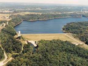
Flood Control Act of 1938. The Louisville District of the U.S. Army Corps of Engineers designed, built, and operates the project to reduce flood damages downstream from the dam. The dam is about 10 miles southeast of
Bloomington, Indiana, on Salt Creek, a tributary of the East Fork White River.
When heavy rains occur, surface water runoff is stored in the lake until the swollen streams and rivers below the dam have receded and can
handle the release of the stored water without damage to lives or property.
|
Dam Information |
|
Pool |
Elevation |
Area |
Length |
|
|
(Feet mean sea level) |
(Acres) |
(Miles) |
|
Winter |
538 |
10,750 |
37 |
|
Summer |
538 |
10,750 |
37 |
|
Total Storage |
556 |
18,450 |
44 |
|
Today's Weather |
|
|
|
|
|
|
|
|
Local Radar |
|
For Boat Rental
or Lodging, Check
the Yellow Pages
Button above.
© 1998 Defcon1, www.lake-monroe.com , Publication and Kevin Plummer. Copyrights for all materials on this web site are held by the individual authors, artists, photographers or creators. Materials may not be reproduced or otherwise distributed without permission of www.lake-monroe.com and the content's original author.
